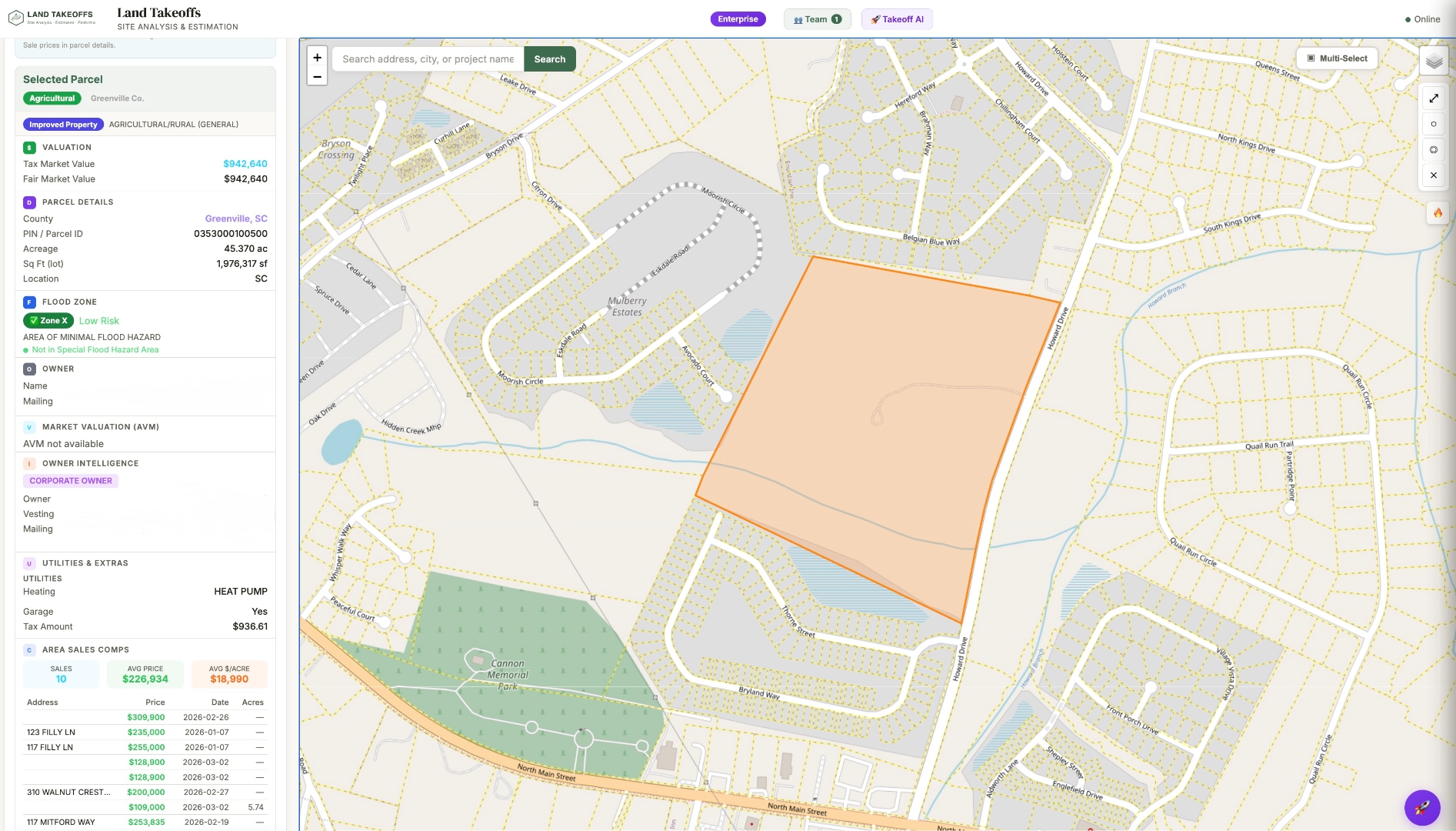
Click any parcel to pull owner info, terrain data, and generate a bid-ready estimate
Know any site before you visit. Click any parcel across 13 Southeast states — get owner data, utility overlays, terrain analysis, and a bid-ready estimate in minutes.
No credit card required. Full access for 7 days.
Click any parcel to pull owner info, terrain data, and generate a bid-ready estimate
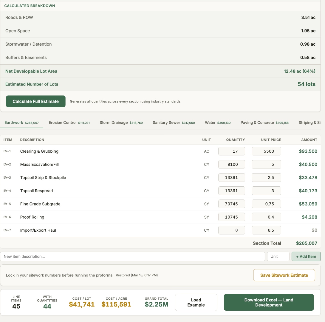
Run terrain analysis, get cut/fill volumes, and generate a 45-line-item bid estimate across 8 categories — all calibrated for the Southeast. Edit quantities, adjust pricing, and export to Excel.
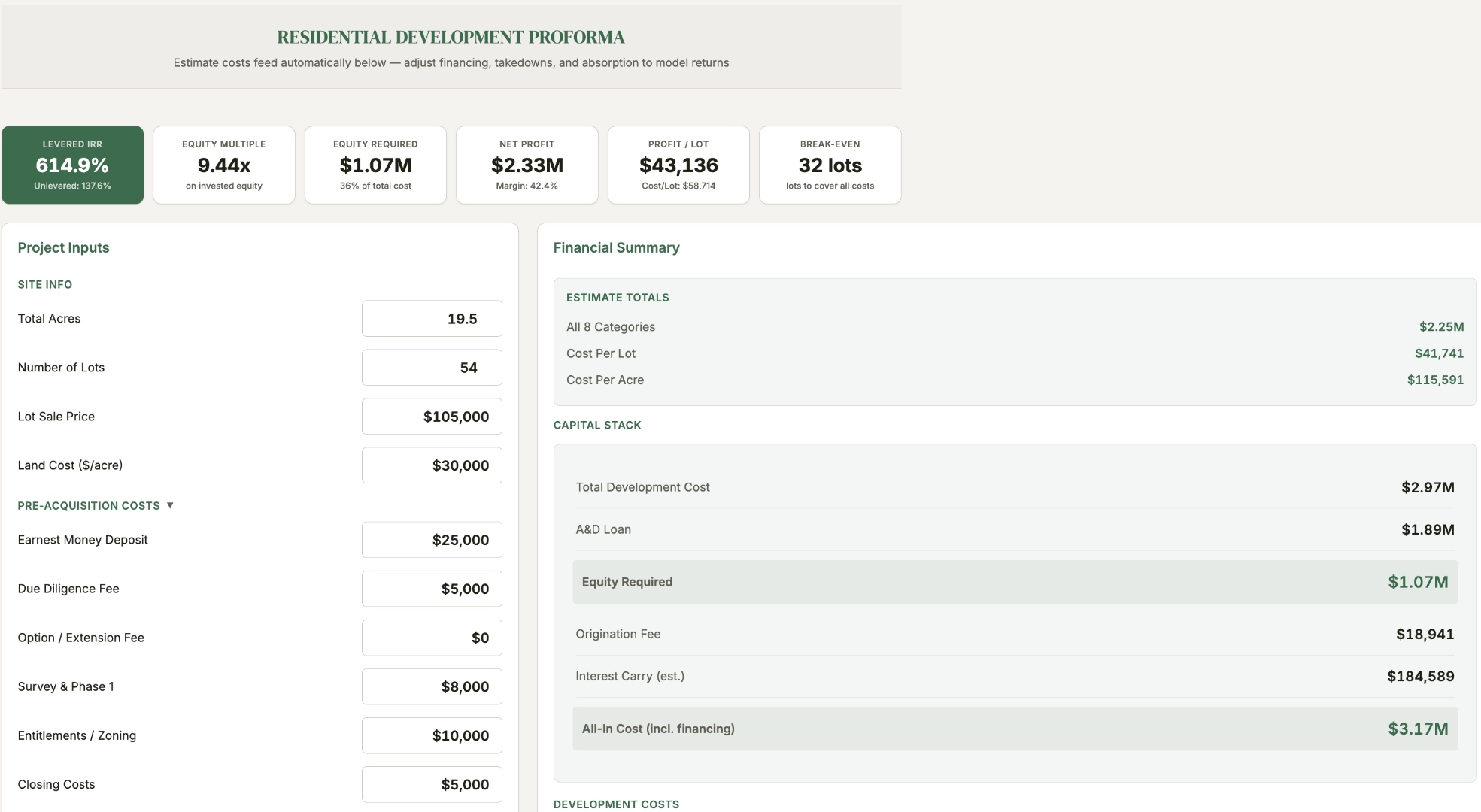
Sitework estimate flows directly into a residential development proforma. Model lot counts, land costs, financing, and absorption to see levered IRR, equity multiple, and break-even lot count — all before you make an offer.
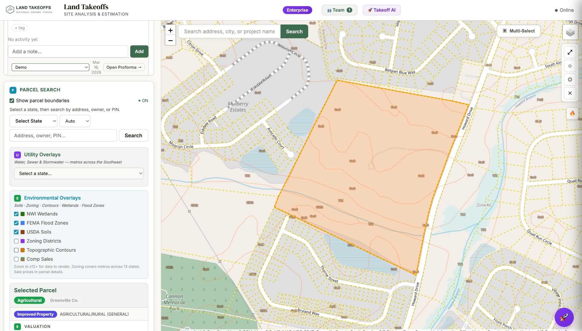
Toggle utility overlays for water, sewer, and stormwater lines. View FEMA flood zones, NWI wetlands, USDA soils, zoning districts, and topographic contours — all layered on top of parcel boundaries.
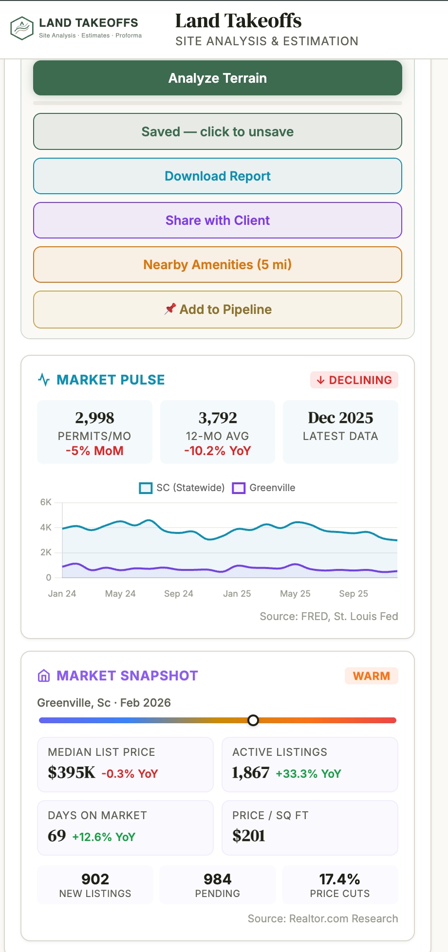
Every parcel includes live market data — building permit trends, median list prices, days on market, and comparable sales. Share reports with clients, track properties in your pipeline, and access nearby amenities analysis.
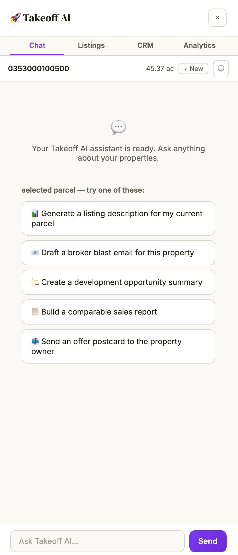
Takeoff AI knows your parcel inside and out. Generate listing descriptions, draft broker blast emails, create development opportunity summaries, build comparable sales reports, or even send offer postcards to property owners — all from a single chat interface.
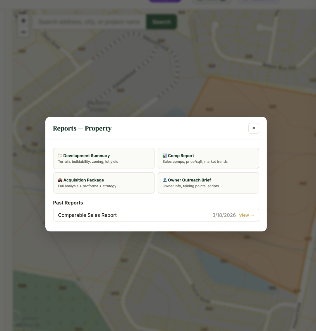
Generate branded development summaries, comp reports, acquisition packages, and owner outreach briefs. Share directly with clients or download as PDF. Your past reports are saved and accessible anytime.
No training needed. Select a site, run the analysis, download your estimate.
Click on any parcel across the Southeast. We pull the boundaries, owner, and property data automatically.
Get elevation, slope, and earthwork analysis. See buildability scores and optimal pad elevations in seconds.
Download a bid-ready estimate in Excel. 45 line items, calibrated to Southeast costs. Ready to send to clients.
Built by licensed contractors who understand the work. No vendor jargon, no bloated features. Just faster, more accurate takeoffs so you can bid smarter and win more.
Whether you're sourcing deals, grading a pad, or evaluating a 200-acre parcel, the workflow fits your role.
Win listings with better intel. Pull parcel data, utility overlays, flood zones, and due diligence reports instantly. Impress clients with data-backed site analysis.
Bid faster, win more. Complete takeoffs in 2 hours instead of 2 days. Accurate estimates win tighter bids.
Site feasibility in minutes. Analyze terrain with USGS data. Validate designs against real topography before scoping work.
Due diligence before you buy. Know site development costs upfront. Make data-backed acquisition decisions.
Review submissions with confidence. Analyze developer proposals with real terrain data. Faster permit reviews.
Try everything free for 7 days. No credit card required.
Full platform access after your 7-day free trial. Cancel anytime.
Then $95/mo. Cancel anytime.
Team collaboration for CRE brokerages and development firms. 3 seat minimum ($447/mo).
7-day free trial included.
A land takeoff is the process of analyzing a parcel of land to estimate development costs — including grading, earthwork, utilities, and site preparation. Traditionally done manually from survey data and plans, Land Takeoffs automates this using GIS data and terrain analysis to produce bid-ready estimates in minutes.
Our terrain analysis uses USGS elevation data with 1/3 arc-second resolution (approximately 10-meter grid). This provides reliable slope analysis, cut/fill volumes, and buildability assessments for preliminary site evaluation and bid estimation. For final engineering, a licensed surveyor should verify on-site conditions.
We currently cover 13 states across the Southeast: South Carolina, North Carolina, Georgia, Tennessee, Virginia, Florida, Texas, Alabama, Mississippi, Kentucky, Arkansas, West Virginia, and Maryland. Parcel boundaries, owner data, and utility overlays are available in all covered states. We're actively expanding coverage.
No. Land Takeoffs is designed for CRE brokers, developers, and contractors who need site analysis without engineering training. Click a parcel, run the analysis, download your estimate. The interface is map-based and intuitive — if you can use Google Maps, you can use Land Takeoffs.
Everything. Full access to all 13 states, parcel data, terrain analysis, utility and environmental overlays, AI Takeoff Agent, PDF due diligence reports, proforma builder, and bid estimate generation. No credit card required. After 7 days, subscribe for $95/month to continue.
Start with a 7-day free trial — no credit card required. After that, the Pro plan is $95/month for individual professionals with full platform access. The Enterprise plan is $149/seat/month (3 seat minimum) for teams that need shared properties, annotations, and client sharing.
Parcel boundaries, owner records, and utility overlays pulled directly from county and state GIS systems.
Pull parcel data, check utilities, analyze terrain, and generate a bid-ready estimate. No training, no setup, no credit card.